Addis Ababa Structure Plan Summary 2017-2027, Robel Yonas, Urban and Regional planner

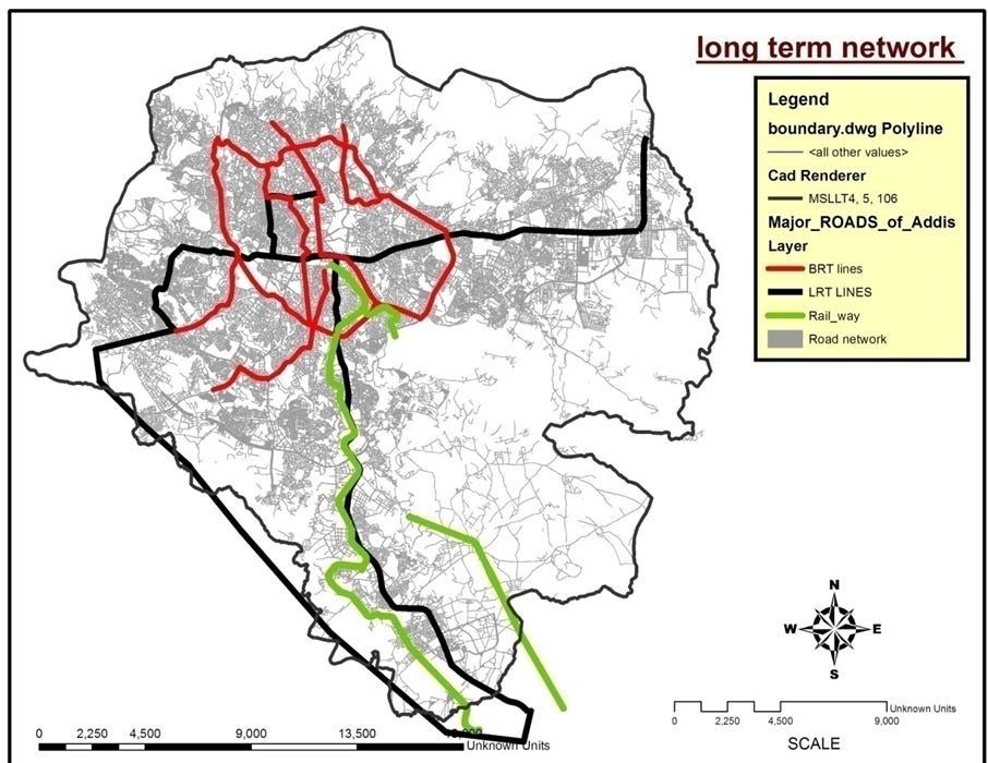
figure 1: Addis Ababa, the capital city of Ethiopia. this map shows The long term mass transport for the city of Addis Ababa have proposed 6 BRT (bus rapid transit routes and two LRT(light rail transit) axis (N-S AND E-W). TOD, It expected to easy car dependency in the city and encourage bus and train uses for commuting. Its also aims is to meet the shortage of public transport in the city.
The Addis Ababa Structure Plan (2017–2027) serves as a legally binding blueprint designed to transform Ethiopia’s capital into a competitive, middle-income economic engine by addressing previous decades of uncontrolled sprawl. To prevent infrastructural paralysis, the strategy shifts the city toward a polycentric urban structure supported by transit-oriented development, mandating high-density housing and commercial activity within walking distance of mass transit lines. Implementing this massive vision requires radical institutional reform, including the creation of specialized agencies and a professionalized city manager role to separate technical execution from political policy. Financing the plan’s ambitious goals—which include building 1.2 million housing units and expanding sewage coverage from 7% to 70% depends on a high-stakes gamble involving local borrowing and private sector investment. Ultimately, the plan seeks to balance modern high-tech industry with social pragmatism, prioritizing pedestrian mobility and environmental restoration to ensure the city’s growth remains sustainable and inclusive.
1. Urban polycentric
2. Transit oriented development
3. Institutional governance reform
4. Massive housing targets
5. Sustainable infrastructure investments
Here is a transcript of a podcast discussing, the Structure plan pillars in depth:
Welcome back to the deep dive. Today we’re not just looking at a document. We are dissecting the actual blueprint for one of Africa’s most dynamic capital cities, Addis Ababa.
That’s right. And this isn’t just any plan. We’re getting into the Addis Ababa city structure plan for 2017 to 2027. It’s this colossal legally binding document with goals stretching all the way to 2040.
So our mission today is to, uh, really cut through all the bargain for you. We want to get to the core proposals and maybe more importantly the implementation strategies. It’s basically the shortcut to understanding the city’s future.
And the ambition here is just staggering. The whole point is to transform Addis Ababa into this competitive economic engine. I mean, the goal is to help Ethiopia reach middle income status. They know if they don’t plan for it now, the growth will just overwhelm them.
Total gridlock.
Exactly. Infrastructural and administrative paralysis. This plan is meant to prevent that.
Okay, let’s dive right in with the foundation. strategy because it’s clear the planners knew the old way of growing just wasn’t working.
No, it was completely unsustainable. They identified a few, uh, really pressing issues. Things like a confused hierarchy between city centers, disappearing green spaces, and what they call unregulated “mixity” of land uses, which is a great bureaucratic term.
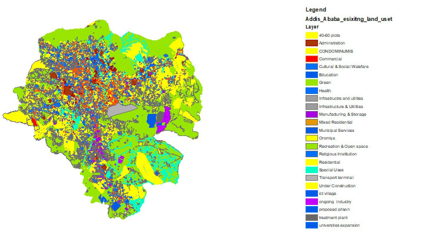
figure 2: Addis Ababa existing land use shows a chaotic mix of land uses 2013.
It is, isn’t it? It just means a chaotic mix of land uses. And the plan really pins this on, you know, past political realities. Development was often inefficient, politically driven, and then We just had this explosive uncontrolled sprawl.
So the new plan is a hard shift. It’s all about integrated development. and it hinges on two big concepts. Transit-oriented urban development to a polycentric city structure. They’re completely interdependent.
TOD is a huge deal for managing sprawl, but it sounds like it needs some serious discipline to pull off.
Oh, absolutely. The plan is very, very specific. It says all new physical development has to be concentrated within walking distance of mass transport, like the LRT or the new BRT lines.
And how close are we talking?
We’re talking about a mandated 100 meter depth linear redevelopment along those routes. The whole idea is to pack people and jobs close to the transit hubs, which makes the transit profitable and saves the green belt.
That’s the theory. But you’re right about the discipline. Imagine trying to enforce that 100 meter rule in existing informally settled areas.
That sounds like an implementation nightmare. Land acquisition compensation.
It is the absolute core conflict. It’s going to take immense political will. But the planners argue that without that density, the entire transport model just falls apart. It’s a kind of financial and spatial discipline that forces the city to grow in a certain way.
And that leads directly to the idea of polycentricity, right? Moving away from one single downtown core.
Yes, it’s a totally pragmatic choice. They looked at the city and saw it had already sprawled out horizontally. There aren’t enough major roads leading to a single center.
So, the existing transport system just can’t handle it.
It’s at capacity, forcing everyone to commute to one central point would just guarantee permanent traffic jams. A monocentric city is a non-starter.
So creating multiple centers is a necessity, not just, you know, a cool design choice. It’s about distributing the load.
Precisely. You build up these secondary and tertiary centers with jobs and services so people don’t have to travel all the way downtown for everything. It reduces commutes and helps manage the growth of the whole metro area.
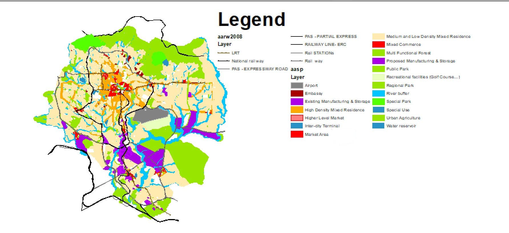
figure3: The Addis Ababa Structure Plan (2017–2027) serves as a legally binding blueprint with major land uses that are compatible with TOD. High rise and high density along major mass transit lines are proposed.
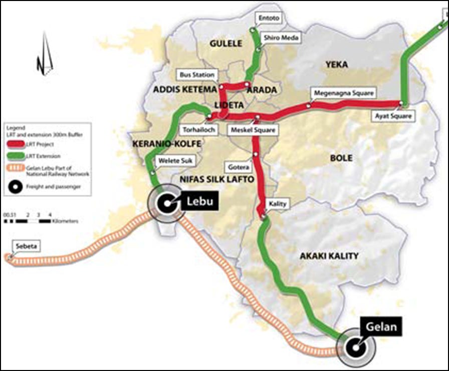
figure 4: Creating a unique identity for the city by using the LRT system. Integrating the new concept of polycentric city with smart growth. Intensification(densification) along the LRT transit route.
Okay, so let’s shift to how they plan to actually run this massive machine. The plan points out some pretty classic governance challenges.
Yeah. Poor coordination between federal and city government and uh, a real blurring of lines between the corporate side delivering services and the political side which is making policy.
And the fix is a pretty radical institutional reform.
It is the plan mandates a very specific model. The strong council strong mayor city manager design and the key here is making the city manager a truly professional non-political role again.
So it had been politicized before.
Exactly. It became a functionary role, not an executive. The new model wants a highly competent city manager who handles the day-to-day operations without political interference.
So, how does that separation of mandates work in practice? What’s the firewall?
The firewall is critical. The political body, the mayor and the council, they stick to the big picture. Policy, legislation, budgets, setting the vision. And the corporate body that’s led by the city manager, they focus purely on execution. service delivery, asset management, especially for services that are meant to recover their own costs, you know, like water and power.
I see. So, you get political direction, but professional efficient delivery.
That’s the goal. And to make sure this all works together, they’re creating four brand new strategic institutions.
Okay. Wait, isn’t creating four new bodies a risk? You could just end up with more bureaucracy.
It’s a huge risk, but the logic is that these are designed to plug specific gaps. They’re not just more of the same. For instance, you get a new plan commission to handle all the high level strategic planning, centralizing it, right? And a development coordination and construction permit authority to create a one-stop shop for permits, hopefully cutting down on delays and corruption. And the other two are focused on the new physical shape of the city.
Exactly. The city centers and corridors development corporation has one job, manage development in those new centers and along the transit lines. It wing fences the most important part of the spatial plan.
And the last one, a green development agency, a dedicated high level body to make sure the environmental goals like river buffers and parks don’t get bulldozed by other projects.
It’s interesting. They also call out staff turnover as a major problem. It sounds like they’re trying to build institutional memory.
Yes, that’s huge. They recognize that constant political appointments have hollowed out expertise. The plan calls for highly incentivized staff retention schemes. You know, better pay, better benefits, plus real succession planning and mentoring.
So, you keep skilled people in the system across political cycles.
That’s the dream. Loyalty to the mission, not just the current mayor.
Okay, let’s talk about the foundation of all of this, the money. The city’s revenue growth leading up to this was actually pretty impressive.
It was tax revenue jumped from about 4.3 billion Ethiopian Birr in 2009 to nearly 17 billion by 2014. That shows the economy was already humming.
And the city is remarkably self-sufficient.
It really is. Almost 98% of its revenue is from its own sources. That’s a major strength. They’re not constantly waiting for handouts from the federal government for their operational budget.
But the type of tax they collect points to a problem, doesn’t it?
It does. Direct income taxes on labor and profits make up 54% of the total. That’s way more than consumption taxes like VAT, which are around 26%.
And why is that a bad thing?
Well, the plan itself says that relying too heavily on direct income tax tends to hinder business expansion. You’re penalizing productivity directly. A healthier system would rely more on consumption taxes which grow more naturally as the economy grows.
Okay, now for the mind-boggling number. The total cost to implement this plan.
It is just a colossal figure. The total estimated expenditure is 880,912.7 million Ethiopian birr So just shy of 881 billion birr.
How on earth do they plan to mobilize that kind of capital?
It requires a completely different way of thinking about municipal finance. The strategy depends massively on non-traditional sources. For starters, they expect local borrowing to cover over 42% of the total.
So around 372 billion birr from borrowing.
Yes. And almost all of that is earmarked for housing and land development which tells you everything about their priorities.
So the city is essentially betting on its own future leveraging its land assets and tax base to issue things like municipal bonds. That feels risky.
It’s hugely risky. It all depends on the city’s credibility. If those new institutions we talked about fail to deliver or if corruption gets in the way, their ability to service that debt is in real trouble. It demands transparency and project management skills they admit are currently weak.
And what about outside money?
That’s the other massive piece of the puzzle. They’re counting on private sector investment to cover another 43% of the total cost about 378 billion birr.
So the government’s role is to provide the framework and the service land and then the private sector has to do most of the actual building.
That’s the gamble. It’s a massive bet on investor confidence in the city’s vision.
So Let’s break down where that 881 billion birr is actually going.
The allocation is very revealing. Land development, which is the city’s job, takes up about a quarter of the budget. And of that quarter, a stunning 81% is just for preparing service land for housing.
So the bottleneck isn’t just money. It’s having plots ready to build on.
Exactly. Then the other 75% of the budget goes to the projects themselves. And of that, 66% is for housing construction. Housing dominates everything. Transport gets 21% environment gets 13%. It’s all about housing.
Okay, which brings us to transforming the physical space. The strategy is clear. Densification and redevelopment of the inner core.
Right? They are out of vacant land. So the only way to go is up. It’s not about small investments. It’s about dramatically increasing how every single plot of land is used.
And this all ties back to that idea of “mixity”, but a controlled regulated version this time.
Yes. A version designed to solve the problems of the old unregulated mix. The goal is to integrate different functions to reduce travel, but also critically to guarantee an increase in residential housing stock in prime areas.
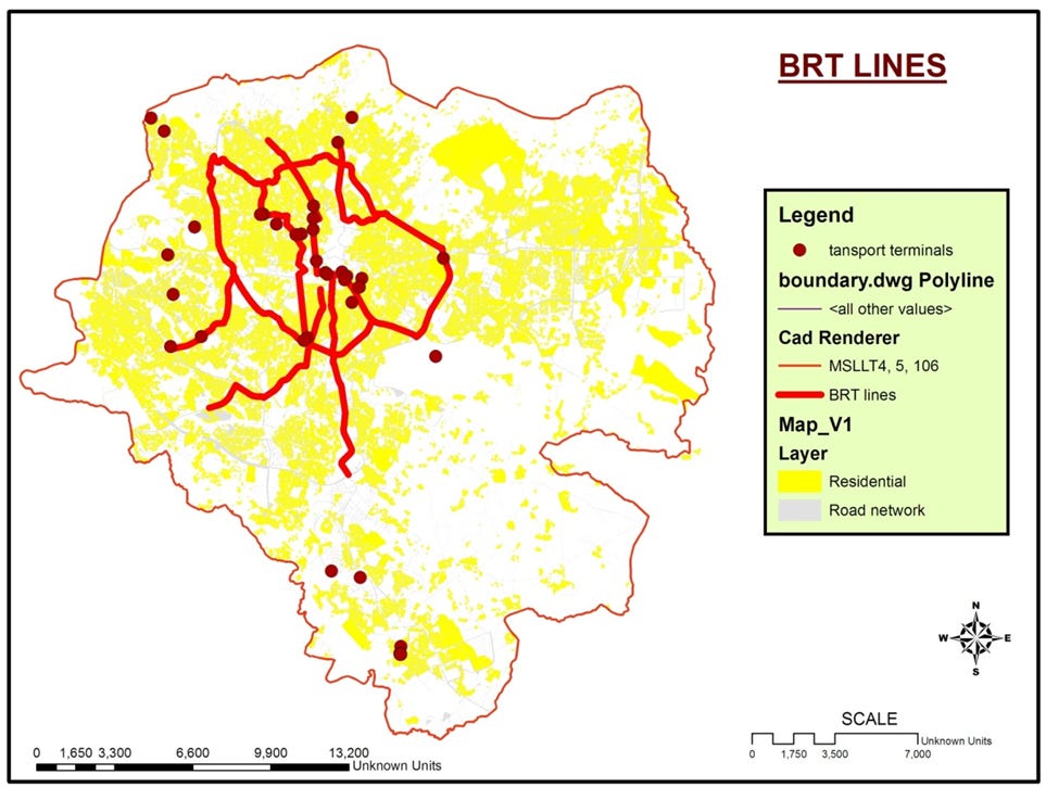
figure 5: BRT(Bus Rapid transit) corridors are designed to feed LRT(Light rail transit) axis, which will enhance mobility and accessibility by providing different choices of transportation for the public.
But how do you stop commercial development, which is usually more profitable, from just pushing all the housing out?
That’s where the specific legally binding proportions come in. In a high-density mixed residential zone, for example, the development must include at least 40% residents. It’s a hard floor.
I see. So you guarantee that people can actually live in these prime transit Accessible areas.
Exactly. And the reverse is also true. In the core commercial and business zones, the residential share is capped at a maximum of 10%.
What about industry? How do they manage factories and workshops that are just scattered around the city?
They’re drawing a very clear line. Any new industry that needs more than 500 square meters is banned from the inner core and residential areas. Full stop.
But they’re not kicking out all small businesses.
No, they’re being pragmatic. Small-scale non-polluting workshops up to 500 square meters can stay. They know the city needs artisans and repair shops, but the bigger polluting factories are all slated for relocation to the new industrial parks.
Okay, let’s talk about the centers themselves. The solution to the old congested single center model is this new hierarchy.
A very clear hierarchy. The main city center or MCC, then secondary, tertiary, and local centers. The goal is to make the whole city more attractive and competitive.
So, let’s focus on the top of that pyramid, the MCC. What’s the vision there?
It’s It’s a complete redevelopment, a high-density CBD over 350 hectares. They’re specifically setting aside 60 hectares of service land for modern offices, high-end retail, and multinational corporations. It’s a direct play to attract international business. And the centerpiece is the big transport hub at “Legehar train terminal”.
Legehar is the physical heart of the whole strategy. It’s a 15 hector site that will integrate everything, regional buses, the national train, LRT, BRT, and even space reserve for a future metro system. It’s the center node.
And what about the big symbolic projects, the ones that signal this is a real transformation?
There are a few. A huge new central park at “Legehar” expanding the historic Space. But the biggest political statement is the plan to convert the massive Ministry of Defense administrative building into a civic and cultural center.
Wow, that is a huge move. Taking a major military building in the heart of the city and turning it over to the public.
It’s an incredible signal. It says the new economic and civic vision for the city overrides old institutional power. It frees up prime real estate and makes a powerful symbolic gesture.
Okay, moving down the ladder to the secondary and tertiary centers.
The three big secondary centers, “Megengna”, and “Jemmo Lebu” are crucial for distributing the load. They’re large 100 to 180 hectares designed to serve a 5 km radius. “Kallity terminal and node ”, for example, is planned to have a massive wholesale market and transport terminal.
So, they become genuine subcenters. So people in the periphery don’t need to go downtown.
That’s the idea. And the tertiary centers are about strengthening what’s already there like a “ ayer tena” or creating new nodes like at “klinto ICT sefer” where they’re deliberately building the center around a new technology university.
A smart move. You anchor a new hub with a high-skill institution.
Exactly. It becomes a magnet for investment and specialized jobs right from the start.
And the actual implementation on the ground happens through what are called local development plans or LDPs.
Yes, the LDPs are where the rubber meets the road. They are legally required to be incredibly detailed. They have to specify the exact residents and job densities, follow the “mixity” rules, and lay out the financial and physical phasing of the project.
They’re like a contract for development.
They are. The plan even talks about signing urban parks with developers to lock in commitments. It’s all about ensuring the grand vision doesn’t just get ignored block by block.
Okay, let’s shift to the big sectoral strategies starting with transport which you said is a whole new paradigm.
It really is. The guiding principle is simple but revolutionary for a city. Increase the capacity of the street to move more people than more vehicles.
So prioritizing mass transit, walking and cycling.
Absolutely. Which is critical because the source material points out that walking is already the dominant mode of transport. A massive 55% of all trips are on foot.
Okay, that’s a point I really want to dig into. If over half the population walks. Is this huge investment in capital intensive projects like LRT and BRT really serving the majority?
That is a fantastic and critical question. The planners would argue first that you need the high-capacity transit to connect the new housing and the new secondary centers. You can’t build 1.2 million homes without a way to move all those people efficiently over longer distances.
And second, the entire TOD strategy depends on it. You can’t justify demanding that hyper density, those minimum FRS of 5 and 10 if you don’t provide the high-capacity transit to support it. The two have to go together.
Okay. So, what does that new mass transit network look like?
They’re expanding the existing LRT, but the big push is for 15 new bus rapid transit lines. BRT is faster and cheaper to build so it can cover the most congested corridors quickly. And they’re also reserving the land for a future metro system, though that’s a 25-year plan.
And for the 55% who walk, what are they getting?
It’s a core priority. The plan mandates dedicated lanes for non-motorized transport almost everywhere inside the inner ring road. Specifically, they’re proposing three pedestrian-only walkways in high-transit commercial areas like the one from “Ras-Mekonen Bridge” to “Degol Square”.
So, they’re actually taking space away from cars
aggressively. That’s the only way to do it. They’re building 28 high-rise parking garages inside the ring road to get cars off the street. And crucially, they are planning to ban on the street parking on all major arterial roads inside that ring road.
A huge change in behavior.
Wow. Okay, let’s move to housing. We know it’s the number one financial priority. What’s the target?
The scale is just breathtaking. The plan is to build 1.2 million housing units in just 10 years. It’s based on a projection that even when the country hits middle income status, 35% of the housing will still need to be for low-income groups.
And this is where we get to the really fascinating part about the types of housing, the typologies.
Yes. It’s this incredible mix of high-tech ambition and grounded pragmatism. For the low-income group, they’re planning subsidized units, but also promoting improved “Chica housing”, which is essentially improved mud brick construction.
Exactly. It’s a recognition of reality. It’s affordable. It uses local materials, and it allows for incremental building, maybe up to two stories. It’s a way to provide shelter for the most vulnerable without waiting for massive concrete towers.
And for the middle class, that’s the majority of the new units, about 600,000 of them. And that will mostly be the standard walkup condominiums, the”20 to 80 type saving schemes” that people are already familiar with.
And this all ties back to the transport strategy.
It’s the core delivery mechanism. All this new housing is concentrated along the transit lines in those 100 meter blocks along the LRT and 50 meter blocks along the BRT. The goal is a density of 150 housing units per hectare to make the transit system viable.
The plan also notes the current institutions for housing are too fragmented.
Yeah, a mess. You have government agencies and private developers all doing their own thing. The plan calls for reorganizing everything under a single umbrella body to streamline the whole process from land acquisition to handing over the keys.
All right, let’s touch on the social side of this. The plan is surprisingly candid about the human cost of this rapid development.
It really is. It talks openly about the problems with displacing farming households on the edge of the city. Compensation is based on old crop prices. There’s corruption. People get extorted just to get what they’re owed.
It creates enormous mistrust.
It does. And for the people moved from inner city slums into the new condos, the problem is different. It’s the loss of the social fabric.
What do you mean by that?
The plan finds that the traditional community support systems, things like a “edir” for funerals or “equib” for saving money together, they’re just falling apart in these anonymous high-rise buildings.
So, people become more isolated.
Exactly. More self-reliant, which sounds good, but it also means less willing to help a neighbor. The plan mentions an anecdote about residents not reacting when a neighbor’s apartment is being robbed. That’s a profound breakdown of social cohesion.
And finally, there’s the very sensitive topic of beggary.
Yes, and it’s important to report this one carefully and impartially. The plan frames it as part of a long-term goal to eradicate poverty. It acknowledges the complexity, noting that a lot of the money collected goes to people who are organized or capable of working.
So, what’s the proposed solution?
It’s a two-step process. First, the city must establish a real social safety net, a social security system for the truly vulnerable like the elderly and disabled. They have to provide institutional support
and only after that’s in place.
Only then can they move to the second highly sensitive step prohibiting street side begging in the main city centers and along major roads. So enforcement is explicitly linked to first providing a genuine alternative.
Okay, let’s pivot to the economy and the environment. The economic development goals are just as ambitious as the housing targets.
Oh, they’re aiming for a fun fundamental societal shift. The goal is to create 1.19 million additional jobs and raise the proportion of the middle class to 50% by 2040.
And the vision for industry is very modern.
Very much so. The vision is to become the most competent IT and related high order manufacturing industrial glomeration in East Africa. They know they can’t compete on heavy land intensive industry anymore. They have to go for high skill, high value sectors which requires building these new specialized industrial parks.
Yes. places like “Klinto and Bole Lemi industrial parks” on over 3,000 hectares of land. These are designed to attract foreign investment and technology and there are strict rules for how these parks operate. Right.
Very strict. The government has to provide 70% of the utilities upfront. A portion of the space 10 -15% has to be reserved for local micro and small enterprises to make sure the benefits are shared. And these parks are where the old polluting industries from the inner city will be relocated.
On the environmental side, given the concerns about losing open space, the Greening targets seem pretty aggressive.
They really are. The target is to reach 5 square meters of accessible green space per person in 10 years and 9 square meters in 25 years. 9 square meters is the WHO (world health organization) standard. So they’re aiming high.
And they have a specific plan for the city’s rivers which have been notoriously polluted.
A very clear mandate, a 50 m wide buffer along all river courses. And these buffers are meant to be active spaces for conservation, for recreation, and even for urban agriculture growing vegetables. and fruit trees.
The waste management strategy also seems like a big step up.
A huge step. The goal is to have three-way waste separation at the source, recyclable, biodegradable, hazardous by 2025. And the big symbolic goal here is to finally close the “Repi dump site, Koshe land fill”, and turn it into a public park.
What about liquid waste? The sewage coverage numbers are shocking.
They are. The source says it was only 7% coverage in 2013, and the plan calls for a massive infrastructure push to get that to 70% coverage by 2025.
Wait. from 7% to 70% in about a decade. Is that even remotely feasible?
That is probably, the single most ambitious and maybe skeptical infrastructure target in the entire document. It requires a pace of construction and capital spending that is just astronomical. If they fail on that one target, a lot of the other environmental goals like cleaning up the rivers become impossible.
And finally in this section, urban agriculture, the plan gives it a surprisingly prominent role.
It does. It’s not is just a temporary use of land. The goal is for urban farming to supply at least 50% of the city’s demand for high-v value products like vegetables, milk, and eggs,
and create half a million jobs in the process.
Exactly. But they’re also being smart about public health. The plan includes educating farmers about the dangers of using untreated waste water and even restricting the growth of high-risk vegetables like lettuce on contaminated land.
Okay, so that’s the vision. Let’s get into the final section, the strategic implementation plan, the how-to. It starts with building height. Yes, the height regulation is the key enforcement tool for the whole densification strategy. It’s all about floor area ratio (FAR) built up area ratio(BAR) and zoning.
The goal being to force efficient use of prime land,
right? To stop developers from just sitting on valuable plots with low-rise buildings, right? And the numbers they’ve set are incredibly aggressive.
How aggressive?
In the main city center, the minimum FAR is 10. That means your total floor area has to be at least 10 times the size of your plot. You have to build tall. In other centers and along transit corridors, the minimum is five.
A minimum of 10. That’s a huge political statement. You’re telling developers, if you want to build in the core, you have to contribute to the city’s density.
It’s the ultimate test of the planning authorities power. And they balance it, too. In historical zones, the maximum FAR is capped at four to protect heritage.
And all of this is subject to the airport’s regulations, of course.
Absolutely. The plan is very clear that civil aviation rules override everything else. Flight paths put a hard cap on building heights in large parts of the city.
Now, let’s talk leasing. How do they plan to roll out 1.2 million housing units?
The government is slated to build half of them, mostly for the low-income groups, but the critical part is the short-term focus, the first 1 to 3 years. The mandate is to develop the land along the LRT and BRT lines first. Housing must follow transit
and the new city centers.
That requires about 30 billion Ethiopian birr and And the plan says they need to immediately set up that new development corporation to fast track land assembly and permitting to get private investment flowing quickly.
The road phasing has some really radical proposals for reclaiming public space.
It does. It’s about using the streets themselves to change behavior. In the first 5 years, the goal is to dedicate the entire road from the National Theater to Legehar to only pedestrians and public transport.
And then in the second 5 years,
they move on to the historic and commercial hearts of the city. “Piaza Adwa Avenue” and the area around “ Mercato the largest open market in Africa” will also be dedicated to only pedestrians and public transport. It’s a fundamental reordering of the city away from the private car.
Of course, a plan this big faces enormous challenges.
It is, which is commendable. It points to three huge systemic threats. Pervasive corruption, a major shortage of skilled people, and a lack of modern management systems. These are the things that could sink the whole enterprise. So success really depends on building public trust to mobilize all that money, especially for the bonds needed for local borrowing.
That’s the crux of it. The government has to become more transparent and accountable. They need to improve tax collection to show they’re credit worthy before they can ask people to buy billions in municipal bonds.
And what’s the immediate focus for building up that skilled workforce they need?
It’s highly technical. They need to train people to prepare those detailed local development plans, to manage the land registry system, to design landscapes, Without upgrading the human capital, the plan just remains a document on a shelf.
So, this has been an incredible deep dive from a minimum FAR of 10 to planning 15 BRT lines to the pragmatism of improved “Chica housing (Mud housing”. This is just a monumental vision.
The detail and the legal force behind it are breathtaking. But that brings us to the final provocative thought. This structure plan is legally binding. Its success or failure will come down to one thing. Whether the political will and the new institution are strong enough to enforce these rules, like a minimum FAR of 10 or closing a massive dump site against the immense pressure of short-term economics and internal corruption. It really is the ultimate test of whether a city can truly plan its way to a better future.